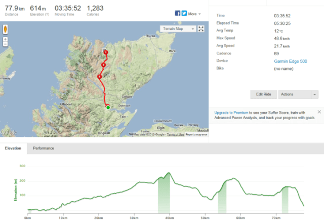
My first attempt at writing trip chronicles was this ubiquitous, legendary trip. I used the website Crazy Guy on a Bike to post my journal. I have since copied the blog across – astounded that there had been 15,900 hits to my journal on that website. If you would like to read some/all of the journal, it appears further down this page (after my introduction), including pictures.
Review (2016):
LEJOG is a legendary trip. It traverses the length of Great Britain from the south west extremity (Lands End, Cornwall) to the north east extremity (John O’Groats, Caithness).
Trips are done for a variety of reasons, but most would involve personal challenges and fulfilment. It is a popular charity route – with English cricketer Ian Botham completing a walk in 1985 for a charity fundraiser. The bike ride has been described as a rite of passage by cyclists, taking on the most iconic and toughest cycling challenge in Britain.
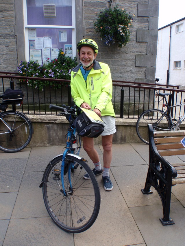
On my trip, we were blessed with Peter Langford – a retired 80 year old Minister from Suffolk, England. Peter was inspirational – he was raising funds for two charities. He had completed LEJOG five years previously, unsupported.
I was in awe of Peter – his quiet and calm persistence, the laborious preparation of his cold bacon sandwich each morning at breakfast, which he would wrap up and carry and eat during the day, his old Dunlop volley shoes, his very old bike which weighed a tonne, his non fuss attitude, and his ability to calm the waters each evening at dinner when discussions became inevitably rambunctious.
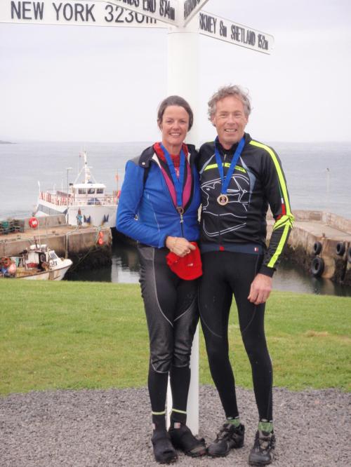
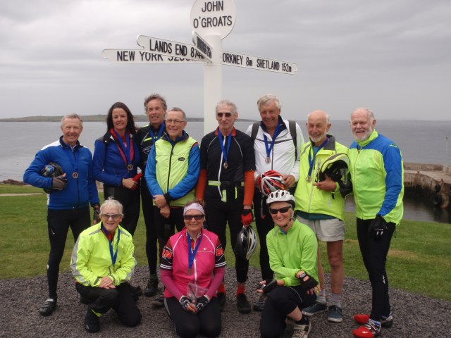
On the final day as we arrived into John O’Groats, we all gathered together – and it was Peter who proudly led us to the finish.
I cried. I was happy to have completed the challenge, but sad that it was over. I am left with memories – of a wonderful trip, great company, biking challenges and lifetime friendships.
The Blog written in 2013:
Getting ready for the long haul: “To sleep, or not to sleep”
Friday August 23, 2013
24 hours out now from our adventure of a lifetime. Crap night sleep last night, as I woke up making mental notes and lists of things to do. I have been pretty organised really – big list at work of what I need to knock off, and an extensive packing list at home. I did my last bit of windtrainer training last night – I have been doing two hours per day now for far too long – the weather has not been kind to us in the last month, and a bout of bronchitis was an extra challenge, not in the training schedule.
I must say I am glad I am done and dusted with the windtrainer – it is soooo boring….
Tony has done a wonderful job packing the bike up – we have purchased the bike boxes as used and recommended by Australian Cycling – that pack flat, which is a requirement of the Bike Adventures tour company. Tony has cable tied everything to an additional corflute panel he purchased. He has packed it with foam from an upholsterer, and bubble wrapped other bits.
The bike box weighs in at 21 kg – the box also has my helmet, shoes and my front travelling bag full of Jemsportz protein bars and Gu!
I really cannot see Tony wanting to unpack these bikes in London for the rides I have planned – to then pack them up again for the train journey to Penzance. Time will tell.
I got into work this morning nice and early – and was very amused and touched by one of my colleagues efforts – I have a series of A4 posters – words of cycling songs, a clever picture of a bike with all the parts named, an Australian cycling jersey, a map of the UK. I am lucky to work with an encouraging and supportive team!!
Jack (maltese dog) left home with us nice and early today – he is all beautifully white and clean – off to stay with Emma for the 5 weeks – he will be very keen to get there and try to assert himself as the alpha male – good luck Jack!
Simba (German Shepherd) is our “gorgeous baby” – she heads off to 5 weeks of obedience training with a lady who lives at Sprent. Simba has been a pupil there, and will be right at home – she may not want to come home!
Tonight we will pack our clothes – what to take? Given we are going from the bottom of England to the top of Scotland, the weather conditions will change heaps – all seasons…
Hoping for a better night sleep tonight – waking up refreshed for that long, long flight….
A very long 48 hours…: Who needs sleep anyway??
Sunday August 25, 2013
Nervousness and excitement ensured a broken night sleep on the day of the long flight. Awake from 5 am my mind is checking and double checking my mental lists. I kept thinking about the comment made by eldest son Joshua the previous night querying the capacity of the Dash 8 to take bike boxes… Surely not I thought!! Qantas did not blink as the boxes were checked right through to London at Devonport airport. Just a casual comment asking what were in the boxes.
As I walked across the Devonport tarmac I chastise myself as the cool air makes me shiver. My warmest jacket for the trip is sitting on the chair in our bedroom!
3 hours sitting in the Qantas Club International lounge and we board our plane. Office mascot Wanda is secured in the over head locker which I am sure is preferable to my squishy suitcase.
14 hours to Dubai and around 1 hour of sleep! I play Who wants to be a Millionaire game thinking of my work colleagues and our daily quiz ritual. I watch a couple of movies and a documentary on Gough Whitlam.
Dubai to London is around 7 hours and for that about 1 hour sleep. My arms annoy me. They ache. Where to put them? Despite the luxury of wonderful leg room purchased at $180 each, I still cannot sleep.
89 kg of luggage cut a very clear path through the throngs at Heathrow. People look at you curiously. Some ask what is in those boxes that are 1.4 x 0.8 x 0.3….battle down the train line to wait and then find out that the line is closed indefinitely. What?? Don’t they know we have not slept properly and not had any coffee to make me a tad more reasonable??
Anyway a maxi cab trip later we arrive at our hotel but cannot check in for 7 hours. We walk. Around 15 km or so later we have walked through Hyde Park, Kensington Gardens, Green Park, St James Park, Westminster, Buckingham Palace, crossed the Thames twice, and back to our Hyde Park accommodation.
Highlight would be the Buckingham Palace tour. 290 bedrooms! Why did we not stay there? Not sure that it looks a great place to kick back in bare feet, place your feet on the coffee table and chill out. Extraordinary wealth in that little family home! Top back yard for a game of footy or cricket! I know I prefer our little low maintenance home devoid of national heirlooms.
We forced ourselves to stay awake until 7 pm… Then hit the sack. Slept well and starving now just waiting for 730 am so we can raid the breakfast area and plan our day. Forecast is a sunny 25 degrees. Quite acceptable. Maybe my Tasmanian winter white arms will start to colour.
Twelve Miles from Lands End: Sick of walking! Time to get on our bike and ride!!
Thursday August 29, 2013
4 fantastic days in London have come to pass. Our final day was spent at Windsor checking out the weekend home of Her Majesty. Nice digs. I may have inadvertently caused a little problem there. We paid extra to climb the Round Tower. For all of you non history buffs, the first Round Tower was constructed by William the Conqueror on a mound surrounded by a moat. As the original tower was in poor knick, Henry II rebuilt it in the 1100’s. The last ten metres was added only a few hundred years ago so it ” looked better”.
Anyway… As I touched a section of the wall from 1170’s, part of it fell out!!!! %%#}%++^###
Very heavily guarded premises….but I live to tell the tale! So if there is a news story about the collapse of the Round Tower you know who is at fault!!
Tony’s knowledge was expanded considerably with our attendance at the very silly but seriously very funny Spamelot. For an old Monty Python fan it is brilliant! We had front row seats. Tony did not fall asleep which was a good sign that he enjoyed it. In his previous life he was dragged along to The Lion King musical, at significant expense… and slept through it!!
We are now in Penzance. The bikes are reassembled and ready to roll. We intend to hit the road after breakfast today and check out the coastline between here and Lands End which includes the Minnack Theatre and some nice coves and old rock placements like a smaller Stonehenge.
We are staying at Sophia ‘s which is a tiny B and B on the Esplanade offering uninterrupted water and coastal views. In the next room, we are told, there are two Aussies, one of whom is also doing LEJOG starting on Sunday. We assume he is “with us” and will meet him shortly.
Met two young blokes at the Penzance train station, sorting out their panniers on their bike. They head off LEJOGing today but doing it in under half the time we are! They are carrying all of their gear including tents.
Prologue: Dusting off the cobwebs
Friday August 30, 2013
Every Tour de France has a prologue so why not ours? Ok we are not the same calibre but it was time to get on our bike to check how it was running and to see how we were after a week of no riding. From Penzance we headed in a south easterly direction towards Helston on a quite busy A394. We had a three mile descent noting that would be fun on the way back into the headwind!
From Helston we were going to head towards Helford as Lyn who owns Sophias told us it was one of her favourite spots. Like all good plans we changed our mind after visiting a cycle shop in Helston to replace Tony’s drink holder that had broken a few miles earlier.
After being offered what was described as a ” very funky” hand made titanium drink holder for £50 Tony chose one for under £5 that is probably 30 grams heavier!! Anyway the guy in this shop asked where we were heading and suggested we ditch that and head to the Lizard! That way we would bag the most southern tip of mainland UK.
On the way we circumnavigated the British Naval Air Services base at Culdrose. A very busy naval airport with an impressive array of choppers taking off, landing and seemingly just flying around. Apparently 3000 people are employed at the base making it the largest employer in Cornwall.
We also passed by Goonhilly Downs which has a large number of satellite dishes and wind turbines. The sign promoted Segway tours and apparently you can climb the largest dish. Reminded me of a problem created by some of my boys when they were younger.
I had a friend whose house backed onto ABC in Launceston. Her children’s cubby house provided the kids with a close up view of ABC’s satellite dish. My friend also had a prolific lemon tree and all the kids were playing in the backyard this particular day in the cubby house… or so we thought!
The next day ABC rang me ( my friend having kindly handed on my phone number as her children could not have participated as they were too well behaved)??!?
The crime? The kids had thrown many, many lemons at the satellite dish using the little probe in the middle as the target! Apparently there were dents in the dish (at this point I am quietly crapping myself wondering how I was going to get out of this. What is a typical repair cost on a satellite dish??)
Thankfully ABC assured me they had used the dish since and it was working well but next time I may not be so lucky!! So stuff climbing Goonhilly dish!!
We detoured to Kennack Sands but should not have. Crappy beach down a very steep and narrow lane with cars galore around.
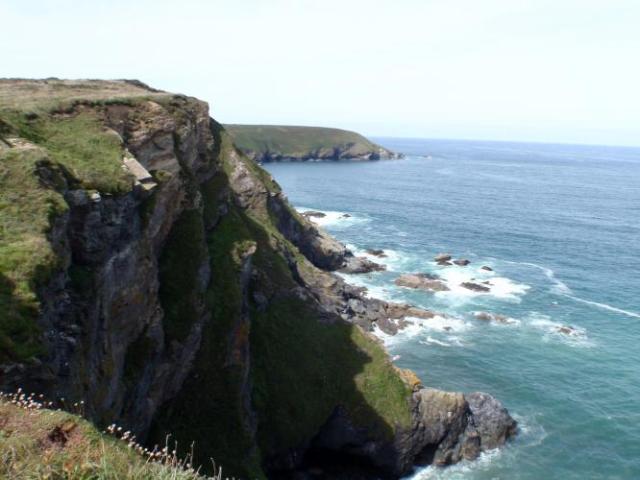
Lizard is a little village stuffed full of eateries and souvenirs. The actual point is worth seeing. Amazing crumbly looking drop offs with goat tracks everywhere. In Australia we would have barriers stopping us going to close to the edge. Here it seems to be encouraged!
The area has a strong history of pirates and smuggling but alas I could not find one!! I was hoping Johnny Depp would appear!! I did sit and watch a seal frolicking in the very clear waters below.
We shared a very tasty and huge Cornish pastie which is far superior to any I have tasted in Australia.
Back to Helston where I was impressed with the cost of our afternoon tea from the supermarket. For the massive sum of 84 pence I acquired 2 bottles of water and 2 bananas. However the supermarket did not stock band aids!!
Some 4 mile out of Penzance we detoured to visit Marazion which is a very old market town from the mid 1200’s having been chartered by Henry III. Cute town with narrow, winding streets and lanes, lovely old stone buildings and great views of St Michaels Mount which has been in use since around 500 AD, later favoured by Monks and now privately owned by a family. How on earth does she get her groceries up that hill??
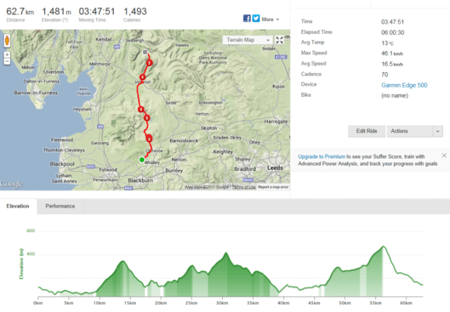
So all in all 105 km done and dusted! We are a bit tired and hopefully will sleep well. Tomorrow we will do a mini second prologue but this time head westerly along the coast towards Land End
Lands End!!: Our time of reckoning is upon us
Saturday August 31, 2013
We took off to Newlyn and Mousehole first thing this morning. Mousehole is a very cute little village with narrow, winding and climbing lanes with tourist wandering around aimlessly. After climbing out of Mousehole we headed off on the back roads to Lamorna Cove which has a nasty descent to the bottom. Nice coastline and a tiny beach. Enjoyed my morning cappuccino here as I contemplated the nasty climb out. It is very narrow and steep.
My initial decision was to walk out but my feet cleated in nicely and I dropped into my small ring quickly so thought I would give it a good crack hoping I would not meet a car as I was not confident about decleating quickly on the steep slope.
I got up the worst of it and came to a bend and a walker descending, and then a damn car also came down over taking the walker and taking up nearly all of the road. When I climb out of bigger hills I swagger the bike around a bit as I pull my arms and push and pull my legs so this was not ideal. I ended up in the wall of bushes to my left which was preferable to the car side. Damage was minimal but I bled profusely from the 4 little puncture wounds courtesy of the teeth on the front gear ring.
From Lamorna Cove we headed straight to Porthcurno to visit the Minnack Theatre which is an extraordinary labour of love by Rowena Cade who has since deceased. She, along with a couple of helpers, created an extraordinary theatre into the side of the Cornish cliff.
The best two beaches to date could be viewed from here and looked very inviting in the heat but a long way down!!
Time was pressing and we needed to get back to Penzance as quickly as we could to meet with Steve from Bike Adventures who kindly collected our gear to transport to Lands End.
Then it was back to Lands End. This time we chose the shorter route along the major road rather than the scenic route. Rolling hills seem the norm in this area and I am convinced my climbing ability is about to improve considerably out of necessity. Despite being only half yesterday’s distance we have climbed a similar amount. Total 54 km today.
We have a great view from our hotel room and I have hand washed our cycling gear from today. It is hanging out our window to dry hoping the wind does not pick it up and carry it to the Scilly Isles.
We will shortly get to meet all of our new riding buddies. Very curiously one of them is riding an electric bike. It appears to be a very heavy bike and seems to me anyway to defeat the challenge of the ride. I will be interested to see how this bike goes. Maybe on the big hills or in a headwind we can use this rider to our benefit!!!
Tea is at 8.15 pm and we are starving!!!
Bring on tomorrow and the next 3 weeks of adventure. May we all ride safely and be blessed with wonderful weather and memories.
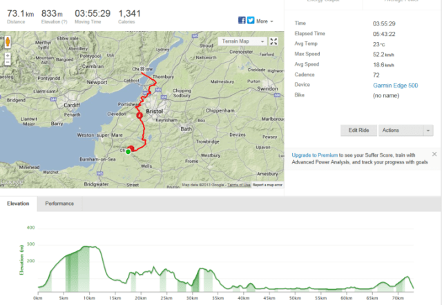
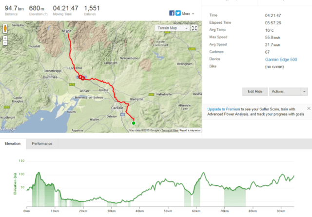
Sunday September 1, 2013, 44 miles (71 km) – Total so far: 44 miles (71 km)
I was nervous this morning. Why? Excitement? Worry about the hills and my ability to do it? I was not alone with my nerves as two of my new riding buddies told me they were too. Helen is from Oklahoma, USA and Jane from Southampton UK. I did not think Jane needed to worry as she has a very interesting bike. It is power assisted. Now that could be handy up hills ! Could we draft off the back of her in a head wind?? There is not a lot of her but using this type of bike opens up the opportunity for her to participate.
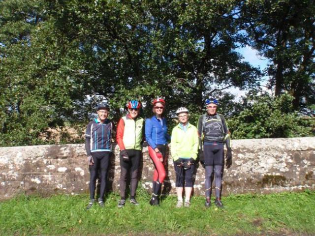
Our team is Yakka’s times two, Helen, Jane, Joyce (London), Peter (a retired Minister living in Suffolk ), Alan (Wales ), Colin (Sydney), Rodney (CapeTown), Ian ( ex pat South African now living in London), Graham (Sydney) backed up by the support team of Phil (sweeper today) and Steve (driver today and the EPO provider (eternal problem obsolver)).
We headed out of Lands End on a glorious morning. The Scilly Isles were faintly visible near the horizon providing a good weather omen.
Out to Sennen, past the Lands End airfield and descending through Kelynack and then climbing up towards St Just followed by a 17% descent.
We climbed and continued along undulating roads through a number of small villages including Trewellard. We past the Geevor Tin Mine and then through Pendeen and Morvah.
The climb ahead was across wild moorland providing great coastal views and photo opportunities. On into Zennor bypassing the edge of St Ives before arriving at the large town of Hayle.
Crossing the bridge at Hayle we managed to lose Graham who was travelling without a GPS and not referring to his riding notes. We rode through the very nice King George V Memorial Walk adjacent to the river. Graham eventually found us.
The next town was Gwithian followed by a climb past the sand dunes. This was a particularly hard climb for me and I did find this quite challenging. I was delighted to make it up but boy my lungs and legs burned! I reenergised with a Gu to find that we stopped for lunch only a few hundred yards later at Hells Mouth Cafe. This spot was recommended by Alan who had recently eaten there with his family. The best ham sandwich ever!! Brilliant views over the road of Hells Mouth which according to Alan is a popular spot to end ones life!
With that somber thought we marched onwards with a steep descent into Portreath. More up and downs including Porthtowan and St Agnes.
With great joy we arrived at Perranporth with Jane hot on our heels (but as I have already learned, one must not refer to her bike as having a motor…it is power assisted pedalling!) We waited for Alan and headed off to our accomodation. The group is split tonight and we are with a bunch at Seiners.
After a shower, Tony and I wandered through town and walked down to the beach where the British National Surf Lifesaving Championships were being conducted. An enormous beach with a massive number of people enjoying the weather.
Great tea at Griffs Grills. Met a couple of retired teachers there who said they much prefer Seiners to where the other guys are… ” but lucky you were not there last night.. huge drunken wedding there with wedding guests being kicked out” We readily agreed! Arriving back at Seiners we enjoyed birthday cake with Rodney and Ian and had a lot of good laughs taking the mickey out of each others countries! For what it is worth they reckon Oscar Pistorius is guilty and will get off! Time will tell.


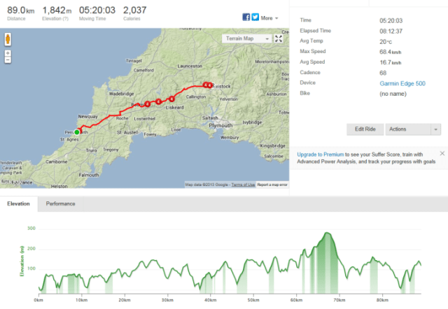
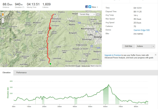
Day 2: Perranporth to Ottery: 1854m climbing. A Personal record!!!
Monday September 2, 2013, 53 miles (85 km) – Total so far: 97 miles (156 km)
Today I proved to myself that I can do anything!! ( Well nearly…). My previous cycling ascents in one day totalled 1100m and when we arrived in Ottery and Tony checked his Garmin to my amazement I had climbed 1854m! (just under 6000 feet). Fantastic! I was so pumped and pleased!!
Again I slept crap and woke up feeling nervous. I knew the day was a tough one and I did not want to let myself down with my own personal goals. I also wanted to keep with Tony as much as possible as I do prefer riding on his wheel.
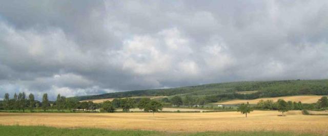
Today we started off as a group in Perranporth immediately climbing out of the picturesque seaside Cornish village…our last bit of ocean until we hit the northern Scottish coast. I am pretty sure we won’t see people sitting on the beach there!!
After 4.2m we arrived at Newlyn East, then up and down until we reached the tiny village of Belowda (15.6m). We had a lengthy stay here waiting for the entire group to rejoin us. A number of us had a toilet pit stop in a paddock. I experienced stinging nettle(??) for the first time as I squatted. It could have been worse!! Fortunately it only got my leg which broke out in a series of little white spots. The good old Reverend Peter gave me some “green stuff” to rub on it as apparently the rubbing action is the remedy. It worked!!
We then regrouped at Bodmin which the EPO Boss told us would be the best option for lunch today. We gathered at Sainsbury’s which had bike racks directly in front of their cafe! Ideal!
I learned here that one must pay more attention to the diagrams on the toilet doors, walking in on some poor old fella doing his thing!!
Upon leaving Bodmin we all took a wrong turn but the benefit was seeing the beautiful old Bodmin church. Bodmin grew up around a large 7th century monastery founded by St Petroc.
The riding group fractured as the afternoon wore on with hills providing significant personal challenges for all…except for the battery powered bike as it just hums up the hills!!!
Tony and myself were joined by Alan, and after a period of time, despite waiting realised we were a fair way ahead. Not wanting our legs to cool down too much with the imminent impending climbs we soldiered on. Big descent into St Neot (34.3m).
It was a steep climb out of the village and we learned that the word level means gentle climbing at times!! But we were becoming hardened cyclists…. Ha ha ha!!
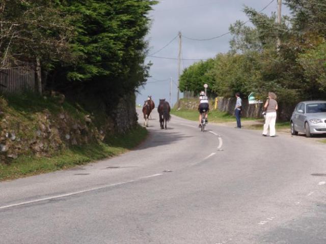
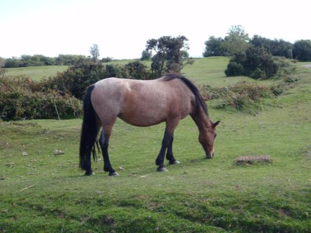
At the 35.8 mark the road climbed steeply for around 1 mile and we witnessed the wild Dartmoor horses wandering around grazing on the side of the road. More photos before descending into Golitha Falls Nature Reserve. Toilets were locked here by the Council due to vandalism. More photos at the pretty river and bridge.
More climbing up onto Bodmin Moor arriving at the village of Minions (40.4m). Minions is the highest point in Cornwall, just under 1000 feet.
Phil the triathlete sweeper was waiting up there looking exhausted from his days work. There is a nice little cafe here serving what looked like very nice scones, jam and cream. However I did not fancy climbing with that for nourishment. Protein bar it was for me, knocking back a very nice looking chocolate bar that Tony had quietly purchased at Bodmin!
The loos here require a 20p coin!! Alan kindly shouted it for me. Turns out the doors were unlocked anyway!
The horses were in plentiful numbers including a very cute foal that I followed up the road on our departure.
Down into Upton Cross (47.1m) with a further descent into Rilla Mill (42.9m). We were surprised upon our descent to see an immediate climb in the heavy traffic of two cars and three people, just dropping down into my small chain ring in time!
More up and downs passing through Bray Shop (a village) descending into Horsebridge(50.0m). More photos here as this village and the Tamar River mark our departure from Cornwall and arrival into Devon. Beautiful bridge from the fifteenth venture provided photo opportunities. I was very impressed with the little niches on the bridge for storing bikes! Those guys 600 years ago thought of everything! So far ahead of their time!!
More climbing arriving at Chipshop (no fish and chip shop in sight) and then our accomodation at Ottery at the 52.9 m mark.
Staying at The Old Coachhouse at Ottery. Can highly recommend this place as a stopover. The very friendly owner put my hand washing through her spinner. The bikes are under the guard of two cocker spaniels! I have heard no barking but hope they are not like my little Jack who would relish the opportunity to cock his leg on each and every bike!!
So roll on for Day 3 where we cross Dartmoor. More climbing!! I am hoping for better defined muscles!
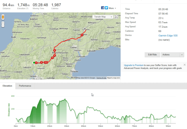
Day 3: Ottery to Sampford Peverell: More hills!
Tuesday September 3, 2013, 59 miles (95 km) – Total so far: 156 miles (251 km)
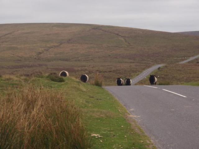
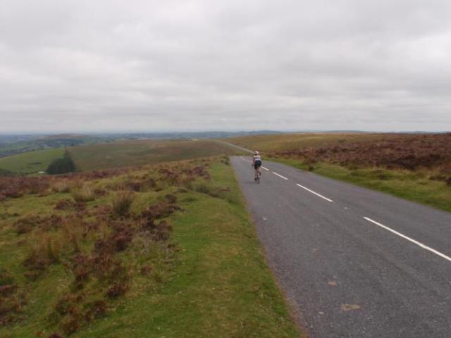
From Ottery we headed towards through the townships of Tavistock (2.5m) entering Dartmoor National Park at the 4.8 mile mark. We steadily climbed up through Dartmoor for many miles. We were fortunate that the day had started overcast providing us with cooler climbing conditions.
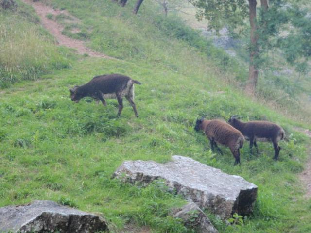
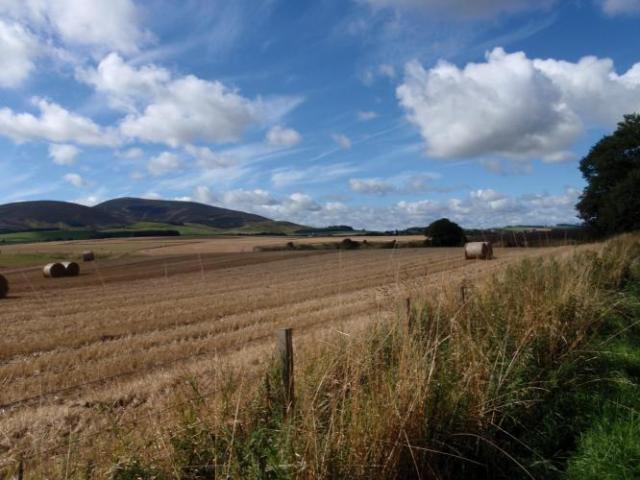
I really enjoyed the wild and open space, populated by wild sheep and cows grazing wherever they wanted.
We waited at the 9.3mile mark for another group of riders to join us before heading down to Two Bridges and then climbing up to Postbridge (17.0 m).
At this stage we were on our own again with Rodney and Ian falling back. We headed to Juraton with a steep descent out of Dartmoor down a narrow farm like road. We passed Gidleigh and crossed over the river on a very narrow old stone bridge.
The course description stated that the road “climbed steeply” and boy they got that right. Tony measured it at 20% and it hurt!!! But I got up it. Just!
At the 25.5 mile mark we made it to Whiddon Down where we stopped for lunch. The Chief EPO was there to greet us and we enjoyed a lengthy one hour break waiting for some of the others to arrive. We waited for Alan and Helen to lunch and rest so they could ride with us for the afternoon session.
The afternoon was quite undulating but certainly easier than the morning. I think the challenge was mixing the 27.5 degree heat with the lumpy course and cumulative muscle fatigue. We worked well as a team and enjoyed more breaks than the morning.
We passed through Yeoford (33.2),Crediton (36.7)and Thorveeton (43.2). At the latter we stopped for a break in the shade of a tree by a little creek and thatched house. Getting low on water we could not locate an obvious source. Then I noted Dave Fiendly the Plumber working at a house. So I asked if he could assist and he kindly filled our bottles. We were most appreciative in the hot conditions.
We crossed the River Exe and travelled into Latchmoor Green (44.1). More undulations and we arrived at Bradninch (48.6). There was a steep 16% climb out of the village into the woods before descending into Cullompton (51.1). A busy town where we also crossed the very busy M5.
The final run to our destination was enjoyable as the sun dropped providing some welcome relief. Our final town was Uffculme (56.5) prior to arriving at Waterloo Cross at Sampford Peverell.
Feeling quite stuffed and light headed tonight! Pleased with my efforts again as I still have not succumbed to walking! Tomorrow we head to Cheddar Gorge in what is apparently an easier day. I think we will all enjoy a recovery day.
D
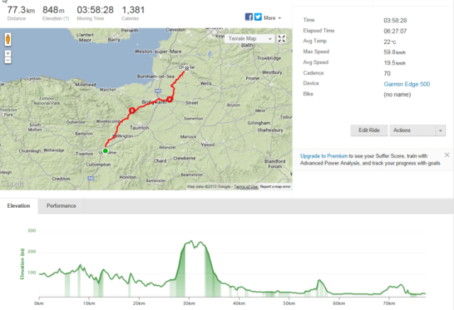
Wednesday September 4, 2013, 48 miles (77 km) – Total so far: 204 miles (328 km)
This is when the day got really tough and I had to pool all of my available physical and mental resources to tackle what was the hardest climb I had done to date. We climbed up through the Quantock Hills for over 1 very tough mile. Our group had fractured with the climb with me following Tony’s flashing rear tail lights (at a growing distance!) until I eventually lost sight of that too.
Totally on my own by now I just kept plugging away. Counting and using my daughter Hannah as inspiration. When the pain in my legs and lungs got worse I talked out loud to myself telling myself that I could do this!
The climb petered out with gentle undulation through the beautiful and cool green canopy. I did get quite concerned when I reached a junction not 100% sure which way Tony had headed but chose to stick to the main road which seemed to be skirting around the Quantocks.
At the 19.8 mile mark there was an intersection and Pines Cafe and I was very relieved to see Tony there talking to triathlete Phil about his bike issues.
I very much enjoyed my recovery break here. Nice cafe with the best apple cake slice with clotted cream ever!!!
Alan arrived on the scene next followed by Helen. The others trickled though over the next hour or so.
From here we descended as an entire group into Bridgewater and with Tony needing to buy some parts from a bike shop, and Rodney wanting protein bars Tony, myself, Helen, Alan, Ian and Rodney peeled off in search of the bike shop. This meant that we would be at the back of the group upon our course return so EPO Steve who was the sweeper for the day travelled with us.
We lost about an hour in Bridgewater and we then enjoyed a fast trip across the Somerset Levels with the added bonus of the EPO course knowledge.
We arrived in Cheddar (47.1miles) with enough time to shower, wash our clothes and head off for a wander around Cheddar village.
Tony and I were joined by Helen and Alan and we enjoyed a chunk of cheddar yarg Helen purchased. I also enjoyed my iced chocolate recovery drink.
The 11 riders split up for tea with three Indians heading to an Indian restaurant and the rest of the cowboys off to a local pub. The meal was the best I have had in the UK so far!
Day 5: Cheddar to Chepstow: Wales! Wonderful navigation by Alan!
Thursday September 5, 2013, 47 miles (76 km) – Total so far: 251 miles (404 km)
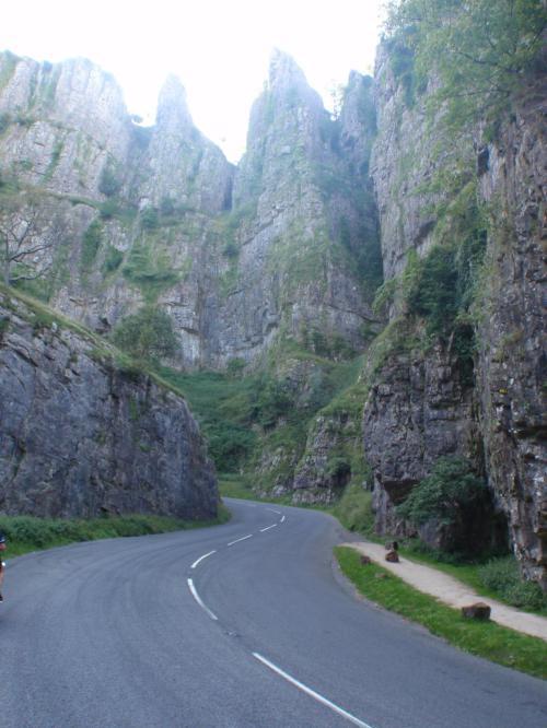
Leaving Cheddar Village we entered Cheddar Gorge which is very speccy. The climb out is quite long at around 3 miles but it was quite comfortable.
You cannot help but to be impressed by the sheer rock on either side of the road, nor the sheep again grazing on the roadside verge. I did think the ambulance was parked too low down the gorge and did suggest to the paramedic he would have a better chance of finding a patient at the top. He offered to follow us up!
With Tony on camera duty I chose to slowly work my way up the Gorge on my own waiting at the top for our now regular group to arrive. First Tony followed by Alan and Helen.
Today was a messy day navigationally speaking. Despite this, our instructions were followed to the letter of the law with great group discussions.
We travelled through Regil (12.8 m), Winford (14.3 m) Failand (19.5 m – nice church here), Portbury, and arriving at Easton in Gordano (23.9 m) where we had a lovely lunch at the Kings Arm Hotel.
Again the 11 riders regrouped with 7 of us heading off together after lunch. The normal gang plus Colin, Joyce and Jane.
We travelled through Pill (24.6 m) before spending some time on the Avenmouth Bridge Avon cycle way and crossing the steep Avonmouth Bridge. We travelled around the back of Shirehampton(26.5 m), Hallen (33.3m), Easter Compton (33.3m) and Olveston (38.2m).
We had dropped Jane many miles before and Joyce “elected” to wait for her. Whilst Jane has the battery assisted bike that is a great asset on the hills enabling her to keep within range, faster descents and open roads are problematic as the battery cuts out at 15 mph and we were travelling faster. Tony is getting increasingly frustrated as the “guilt” factor creeps in. He wants us to be able to “do our own thing” and not feel obliged to keep stopping and waiting for so long as we the cool down too much. We wish she would sit with the sweeper but not sure what to do without causing angst all around.
Full marks to Alan today for his wonderful navigation to the Severn Bridge!
We arrived in Chepstow in plenty of time to again shower and wash our clothes and head out for a look around town. We checked out the Castle exterior and wandered through town and also took the opportunity to walk over the river back into England and then back into Wales.
Day 6: Chepstow to Weobley: Am I getting fitter or is the riding getting easier?
Friday September 6, 2013, 53 miles (85 km) – Total so far: 304 miles (489 km)
Certainly today was not as taxing as the first few days. It does make me wonder whether it is because I am getting more cycling fit as I go, or whether it is the course, or perhaps a combination of the two.The forecast looked dodgy weather wise. Mixed weather reports ranged from just plain awful to maybe not so bad. It appeared to me that we were on the fringe of a rainy pattern over most of Wales and parts of Western England. It had been drizzling but by the time we left Chepstow it had stopped. It was certainly cooler than the previous days.
After climbing out of Chepstow, we rode along the Wye Valley which was majestic and a wonderful ride. We stopped for a while to appreciate the splendour of Tintern Abbey before heading towards Monmouth.
The group today consisted of Yakka’s x 2, Alan, Helen, Colin and for some time Joyce.
We stopped at The Black Swan for lunch which proved to be a hoot. Having been turned away by the pub at the previous village due to the sewing class that was being held (!), we knocked on the front door of this one to see if they were open. They were very friendly and welcoming but did not want us sitting in the bar area as the locals may get upset if their favourite and usual seat was not available!
Ian went to check out the locals and decided that the two already in residence were perhaps drinking formaldehyde given their lack of movement and acknowledgement!
I only had soup for lunch and subsequently made a mental note to eat more substantially at lunch as I spent the rest of the day hungry.
We travelled through Tyberton (38.5m), Moccas (41.5m) and Brewardine (43.7). Soon thereafter we crossed over the River Wye heading towards Staunton on Wye (46.2).
The day was not over taxing hill wise although some managed to remind my tired quads that they have room for improvement with strengthening.
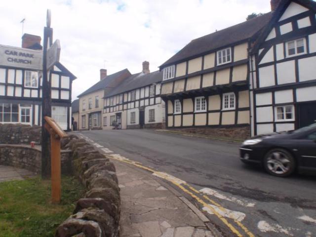
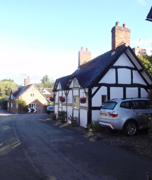
Final destination today was Weobley where we are staying at a wonderful quirky B &B The Gables. Weobley is known for its Tudor black and white heritage houses, as is the home we are in complete with four poster bed.

Day 7: Weobley to Bomere Heath: Relatively easy day in cooler conditions but no rain!!
Saturday September 7, 2013, 55 miles (89 km) – Total so far: 359 miles (578 km)
We left Weobley this morning not sure what the weather would be doing, but the temperature was certainly cooler than the previous week. It was 7 degrees C. Long fingered gloves and skull cap came out but still in short knicks. Today was a continual day of undulations but nothing too taxing.
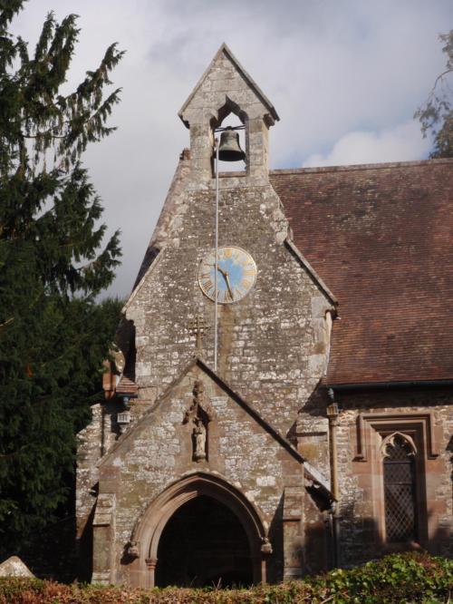
Villages travelled through included Luntley (4.1m), Pembridge (5.9m), Staunton on Arrow (8.2m), Lingen (13.7m), Birtley (15.0m) arriving in the lovely little village of Brampton Bryan (17.2m). This was our first stop of the morning as this village has a pretty church with an amazingly trimmed hedge.
Next villages included Bucknell (18.9m), Bedstone (20.5m), Hopton Castle (22.2m), Twitchen (23.0m), Purslow (24.5m), arriving in Wentnor around 12 noon, just in time for a bite of lunch at the local pub.
Great bacon and cheese panini and the best ever hot chocolate was enjoyed along with a break of just over one hour during which time the rest of the gang rolled in.
Upon leaving there were 7 of us but after only 5 miles of hillier terrain 3 remained (including Alan). We waited at the top of the rise before turning off towards Westcott. After around 10 minutes we were actually quite concerned as we did not believe that we could possibly have pulled that much of a gap.
We ummed and aahed for a bit and I offered to ride back to check out the state of play. The boys felt that they must have taken a wrong turn and said it could be pointless if that was the case. So we rode on, although I felt a bit guilty.
The afternoon riding was generally easier than the morning and our average picked up. We headed to Pontesbury ( 43.3m) and then Montford Bridge (50.7m), where we again crossed the River Severn.
We turned towards Mytton and Fitz before arriving at accomodation at Bomere Heath.
This joint is owned by a Lord and Lady. The Lord came out and introduced himself and then proceeded to reel off a list of “house rules” telling us that cyclists were on their last legs with him as he had previously had bad experiences. He felt the need to elaborate about some female cyclist who had fallen asleep on her bed with wet cycling clothes…allegedly resulting in him throwing out £200 worth of linen.
What a shame Tony and I were staying elsewhere that night! Poor old Alan had to fess up though that he was a guest there and would comply!
Our hotel was a number of miles up the road at Burlton Inn in Burlton. Great room and no house rules! The gang came up for tea and we also got to meet Ian’s son who had ridden with him from Leominster today.
Day 8: Bomere Heath to Acton Bridge: Tony’s get up and go, got up and went!
Sunday September 8, 2013, 49 miles (79 km) – Total so far: 408 miles (656 km)
We had a later start today due to our accomodation having an 8.30 am breakfast. Tony had a bad night, suffering from gastro badly and not getting much sleep. Tony had no breakfast and left complete with a roll of toilet paper in his backpack! In the van we headed back to Bomere Heath passing Jane who had taken the opportunity of leaving early. Alan, Helen and Joyce had also hit the road and were some miles ahead.
Colin, Tony and myself worked as a group, going at Tony’s pace, which was considerably slower than previous days.
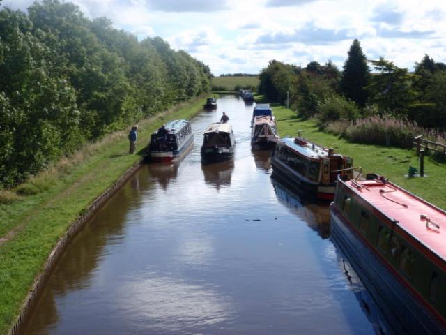
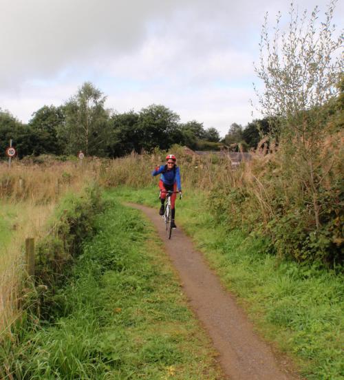
On the bikes we then headed back towards our previous nights accomodation travelling through Merrington (1.4m), Northwood (10.5m), Bettesfield (11.8). At Bettesfield we crossed the Shropshire Union Canal. We stopped to take photographs and have a chat to a couple of guys on one of the canals.
Stopping at the Malpas general store (21.1m)I picked up some Imodium as Tony had already eaten 4 today and also having stopped in a paddock on the way. With the cafe closed on Sundays we made the decision to press ahead.
The morning ride was very easy which was definitely beneficial for Tony.
The afternoon was a little lumpier but very easy.
We caught up to Alan, Helen and Joyce early afternoon and rode together stopping to enjoy the view of Beeston Castle which is built on a very prominent, rocky crag. Further around the vista revealed a prominent castle turret built in more modern times, also doubling as the film set for the movie Robin Hood.
We then followed the Chesire Cycleway crossing over a canal and passing through another Tiverton, having passed through the Tiverton near Dartmoor last week.
We stopped for a rest at The Shady Oak adjacent to a canal. Tony managed to have a gel and some lemonade for his first nourishment for the day.
We headed off with rain threatening and we actually stopped to put our rain jackets on, but they did not last long with only about 10 minutes of light drizzle being experienced.
We past through Tarporley (34.8m) and Utkinton (37.0) climbing steeply out of the village. We then descended steeply having a chat to a couple of guys acting as stewards in an equestrian event. “Sorry about the cricket!”. Heard that a few times recently.
We rode through Delamere Forest which was very green and shady.
At 42.2m we rode through Hatchmere and Crowton (44.7m) arriving at Acton Bridge, crossing the Mersey Canal and climbing through the woods. We arrived at our accomodation at the Holly Bush at around 2.30pm.
Phil rocked up shortly thereafter and found out that Ian and Graham had an accident with each others bikes resulting in some cuts and grazes.
Day 9: Acton Bridge to Hurst Green: UK Baptism
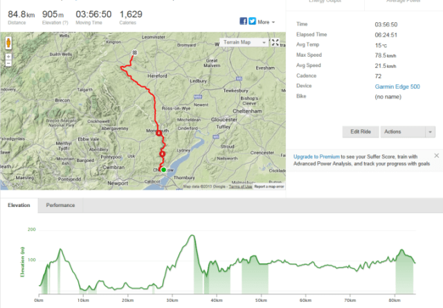
Monday September 9, 2013, 60 miles (97 km) – Total so far: 468 miles (753 km)
Got wet today for the first time in over two weeks in the UK. Had to happen I guess and it could have been worse. We experienced two downpours that were stinging but they did not last that long and then the sun came out. Bit like Melbourne really!
Today was scheduled as a longer day of 59.5 miles including a tougher afternoon. Six of us set off together and I was determined that this group should stick together. I felt a debt of gratitude to Colin for the support and encouragement he gave Tony the previous day. We also had Joyce who had just discovered she actually had a third chain ring.
We left our overnight accommodation in Acton Bridge heading through Comberbach (2.7m) and Budworth (4.0m) stopping to take a couple of photos of some lovely little homes. Alan was leading as he said he knew this area very well and we were happy to let him navigate us.
We passed an “ice cream farm” pondering the choice of phrase but being very fond of ice cream thought that perhaps we too could have “ice cream farms” in Tasmania!
At 9.1 mile we passed through High Legh and crossed the M56. At Broomedge we rode under the Bridgewater Canal which I also thought curious.
We rode though Warburton ( 12.9 m) riding towards the toll boom gates to cross the Manchester Ship Canal. It costs 25 pence for cars to cross but free for bikes. More photos on the canal bridge. Apparently the canal was hand constructed to allow ships to transport goods from the land locked Manchester out to sea.
Enjoying the easy riding we rode through Hollins Green (14.1m), Glazebrook (15.7m), and Culcheth (18.5 m).
The traffic situation changed considerably at this point and was to be experienced for the next 15 miles or so.
Glazebury was at 19.7m and we stopped at Bents Garden Centre (20.3m). This would have to be the hugest garden centre I have ever seen. After negotiating the considerable Christmas card section we found the so called cafeteria which had amazing food and about 3 different seating areas. I did not see 1 plant….I guess one would need to take their compass and venture deeper into the heart of the complex.
After crossing another canal we passed through Leigh (21.5m) and a bit further on an industrial park which in one spot promoted the first zero energy use industrial park complete with wind turbines and solar panels.
Somewhere in this mix I failed to decleat quickly as Alan came to a blinding stop and I was too close to his rear wheel. Over I went with some small grazes and sore hip and thumb. Guess that will be a bit stiffer tomorrow.
Hindley is quite a busy centre which we passed through at the 25.0 mile mark, followed by Aspull (29.6m), Haigh (30.3 m), Blackrod (31.8m), stopping at Rivington (34.8m) for lunch at the Church Hall. Very quaint with lots of customers and their dogs.
Tougher afternoon with 2.2 mile of climbing straight after lunch with cold legs. The climb was made more entertaining by the painting of names on the road cheering on cyclists from a recent road race. The closest to my name was “Go Sheila!”. Guess that would have to suffice.
It was very satisfying to reach the top not feeling too pained! That would come tomorrow! The moors at the top were very open with scraggy looking sheep just cruising around wherever. Think the hill is known as Winter Hill.
A nice decent to Belmont (38.3m) through the village and past the reservoir.
The road then climbed and descended to Tockholes (43.1m) by which time we had our rain jackets on and had experienced a sharp, solid and stinging downfall of rain.
We turned into a Council housing estate which revealed a number of houses where it appeared the occupants were not particularly house proud.
At 46.6 m we rode through Pleasington before arriving at the outer part of Blackburn. More ups and downs including an unanticipated climb through and out of Clayton-le-dale (54.4) just to finish the legs off. Silly me decided to challenge Tony on these hills catching up to him with some capacity left in the legs. He was obviously feeling heaps better as he just put his foot down and owned the hill! .
Thunder claps were sounding in the not too far distance and we were keen to get to our accomodation before the next downpour.
We were all very pleased to arrive at The Shireburn Arms Hotel in Hurst Green ( 59.5 m).
Day 10: Hurst Green to Dent: Hills are like childbirth!
Tuesday September 10, 2013, 40 miles (64 km) – Total so far: 508 miles (817 km)
Hills are like childbirth because you forget just how painful it is until you go back for another dose! Today was damn hard. Well I thought it was! A lot less miles were completed and about 1450 metres total ascent is not as significant as some other days. Nevertheless I thought it was hard! The rain stayed away but it was cold. We also had a strong headwind for most of the ride to add to the challenge.
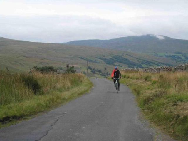
We left our Hurst Green accomodation with our now regular travelling group full of chat. We headed to Waddington (5.9m) climbing into the Forest of Bowland. Reasonably treeless and open moors with a history of hunting according to our local guide Alan.
We kept climbing reaching the top of the climb at the 8.9m mark. We then past through Newton-in-Bowland (11.1 m) climbing further to Slaidburn (12.9m).
We continued climbing crossing into North Yorkshire. After crossing the river we climbed further to reach High Bentham (25.0m) where we stopped for lunch.
After a decent lunch break with yummy food we climbed out of town and then descended into Ingleton.
We passed under a very historic looking viaduct.
After Thorton-in-Londsdale (29.3m) we climbed over the hill and continued along the broad river valley. At the farmhouse we had to stop to open and close a gate with the road then climbing steeply.
This was a tough ride to the top of this section of the Yorkshire Dales. The road is noted as “Quiet Lane” and that it was! I think I saw 2 cars moving in this section which is fortunate as I did not want to meet one on the narrow and steep sections.
This climb hurt. My legs burned and my back was starting to cramp up probably due to positioning and how tight I was gripping the bike.
After reaching the top and waiting for the the others Tony and I froze. It was icy cold. But the views were great. The hill tops are barren and denuded of vegetation as they are below the snow line. The sheep graze wherever, not being constrained by fencing.
Once we regrouped the descent commenced and we were very slow and careful, particularly given our EPOs earlier words of advice noting the death of a cyclist who descended too fast and crashed into a gate. The view of the green valley that came into view was stunning, and a contrast to what we had viewed from the top.
The descent was steep and scary and we allowed good gaps between each rider. In several spots there are closed gates including one just after a steep turn. The waterfall at the 36.7m mark is certainly worth stopping to admire.
We continued to descend into Dent (39.3m) but chose to walk our bikes on the rough cobbles through the quaint and pretty village.
After a shower we went for a wander around this delightful little town which has a history of knitting. I purchased a woollen red hat. Apparently in the 18th century both men and women knitted, often whislt walking to the fields. Their output of hand knitted gloves and socks was enormous, providing an important supplementary income.
We also checked out the local 12th Century church of St Andrews, where you can still see Norman features in the tower, the nave and the arched doorway.
Tea was a hoot as we celebrated Ian’s 66th birthday with a cake that Bike Adventures purchased. Jane thought that she should have a birthday too so we could share cake with her, despite her birthday being in June. The subsequent conversations that ensued were just plain funny as Jane vehemently continued with her somewhat serious protestations. I must remember to keep my eyes out for anti-sarcasm tablets.
Tomorrow sounds like it is going to be crucifying for me personally. Will see. I will do my best. If that is not good enough then I will just have to walk that bit of nasty hill.
Day 11:Dent to Armathwaite: The day of reckoning!
Wednesday September 11, 2013, 56 miles (90 km) – Total so far: 564 miles (908 km)
I had an aim of riding LEJOG without getting off my bike and walking. Today we had what our EPO regards as the toughest climb of our LEJOG route climbing from Cowgill, up past Dent Railway Station to the top of the 3.2mile climb. Dent Station is the highest railway station in the United Kingdom.
As we departed Dent today I was nervous and said to myself that I needed to make safe and sensible decisions today. Since the age of 9 I have coped with exercise induced asthma. As a kid I was wrapped in cotton wool by my parents who actively encouraged my non activity. I rebelled as a teenager and ended up doing track and field running, cross country running, hockey and table tennis.
I progressed to bush walking and caving and enlisted with the Australian Army Reserve so I could earn enough money to buy my wind surfer. My chain smoking parents were horrified.
I “forgot” to tell the Australian Defence Force about my asthma but got caught out when exposed to tear gas. Tear gas is a great asthma trigger!!
I am also stubborn and expect a lot from myself. I worked hard for 2 years to overcome a knee reconstruction and I don’t like to be told I cannot do something.
I wanted to beat this hill but knew I needed to listen to my body. I was doing quite well up the hill and had conquered the hair pin bends but my lungs just would not comply and the cold and moist air along with extreme physical exertion just sent them into broncho spasm. I was all alone (as Tony was a few hundred yards ahead) and the others were at least a similar gap back, and this was not the time or place to collapse…so the inner and more sensible voice eventually won telling me to stop and I got off the bike and walked around 150 yards.
However, I was gutted and bitterly disappointed! I worked hard to get my breathing calmer and more relaxed along with extra ventolin and rode the rest of the climb and met Tony at the top which is 535 m / 1750 feet.
The rest of the days ride was much easier and just rolled along and I treated it as a recovery ride.
At the 11.8m mark we crossed into Cumbria, followed by Outgill (15.3m), Nateby (18.9m) and Kirkby Stephen (19.9). We stopped for some welcome morning tea here.
Other towns and villages included Soulby (22.5m), Burrels (29.2m), Appleby-in-Westmoreland (30.1m), Long Marton (33.7m), Newbiggin (38.2m), Culgaith (40.4m), Langwathby (44.1m), Great Salkeld ( 47.3m) and Lazonby (49.2m).
The day from Kirkby Stephen was damp with rain experienced for the majority of the rest of the days route. We opted to not stop for lunch but just to roll along steadily.
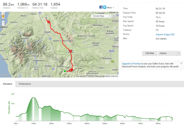
We were glad to arrive at Armathwaite, having ridden 55.1 miles and climbing nearly 1200 metres.
Day 12: Armathwaite to Moffat: Easy Day!
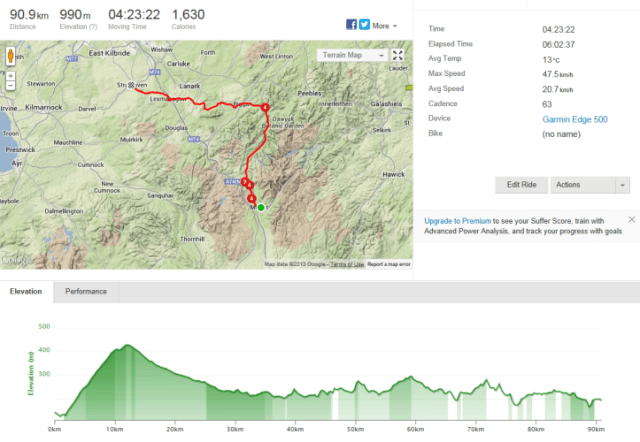
Thursday September 12, 2013, 60 miles (97 km) – Total so far: 624 miles (1,004 km)
Today was a contrast to yesterday morning. Easy! From our overnight accommodation in Armathwaite we continued alongside the valley, crossing the railway and climbing steeply with our stiff and cold muscles protesting the prematurity of use!
At 7.1m we rode through Wetheral with the road descending out of town and continuing alongside the river.
At 9.0 m we arrived at Warwick Bridge then 9.3m Little Corby, turning left at River Irthing.
In quick succession Newby East (10.0m) and Low Crosby ( 12.2m) we were enjoying our very relaxed and casual riding style today. I think the imminence of the following day being a rest day put us into holiday mode a day early. At times I found the pace too slow and had to exercise some patience.
From about 13.7 miles signage started to signify our impending border crossing into Scotland and we were all genuinely excited by this prospect. EPO Steve had forewarned us that there would be no “welcome to Scotland” sign which I think probably disappointed us as we were keen to be photographed at such a sign.
We travelled along a small section of cinder cycle path which was a narrow tract of dirt between grass. Tony bolted ahead at this point enjoying the rougher ride.
After passing through some woods we arrived at Longtown (21.9m) where we stopped for morning tea at a cafe. All except electric Jane, Rev Peter and Aussie Graham stopped here.
There was also a bike shop in Longtown on the outskirts so our group checked it out and Tony and I stocked up on protein bars, gels and bike cleaning products.
We rode over the River Esk where I could see a couple of fly fisherman wading through the shallow waters.
At the 25.2m mark we crossed the River Sark which denotes the Scottish border. Obligatory photos ensued and I must say the Scottish farmers make it difficult to have a pee here. Fences with barbed wire and plenty of stinging nettle!
Chapel Knowe (28.1m) was next, followed by Eaglesfield (33.7m) and then the wonderfully named Ecclefechan (36.5m), famous as the birth place of poet Robert Carslyle. We were getting peckish again but there was no obviously open and enticing eating place.
We saw Triathlete Phil in the support van just out of the village so stopped and had a bar and banana there before heading off again towards Lockerbie.
The pace picked up at this point with Tony and Alan leading and we dropped Colin and Joyce. The boys were in a no waiting mood at each intersection and I did feel a bit guilty as I knew Colin would be disappointed with us.
The boys then undertook an 8 mile time trial. The pace was fast. Very fast as we zipped along the highway. I did wonder how long this sudden burst was planned for as my recovery ride turned into a non recovery effort. The miles were ticking by very quickly here. Helen said she did not mind if I left her and went up behind the boys.
I told her I would stay knowing that my presence behind Tony would make him go up yet another level due to his competitive nature.
Helen and I were both relieved when the time trial came to an end turning off the highway.
For the last 10 mile the pace was again very cruisey and easy enjoying the Scottish country side that was increasingly aesthetically pleasing.
At 59.9 miles we arrived at our accomodation in Moffat, “Bridge House” which is a delightful B & B owned by an equally lovely lady. Our room was above and beyond expectation with a lovely bay window and four poster bed. Weeks worth of dirty washing was done and dried for £10 within only 2 hours of our arrival.
A few of us went for a wander into Moffat village where we sampled a piece of the renowned Moffat toffee.
Tea was at Claudio’s, a local Italian restaurant. Highly recommended. The waitress there was memorable for her strong Scottish tongue! She also told us what a lovely couple Rev Peter and electric Jane were (they had arrived earlier at a different table). That brought a response from our table she could not have envisaged or even understood.
Day 13: Moffat to Strathaven: Calm before the storm?
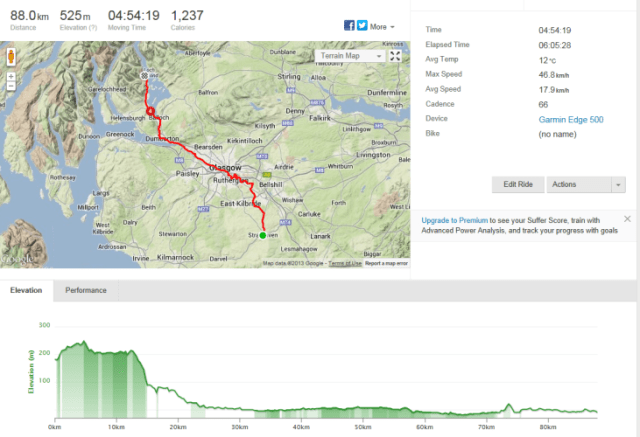
Friday September 13, 2013, 57 miles (92 km) – Total so far: 681 miles (1,096 km)
After our first and only rest day scheduled for our LEJOG Tour de UK, we were ready and keen to roll this morning. The weather had improved overnight and we were blessed with a bit of blue sky and sun. The air was very crisp around 7 degrees.We undertook an initial 7 mile climb out of Moffat and what a beautiful climb! Unlike the English who like to put the most direct route up a hill and toss in a few hair pins for good measure, this Scottish climb is gentle and goes on and up gently for the 7 mile providing the cyclist with brilliant views of the Tweedsmuir Hills.
We also passed the source of the River Tweed marked with a headstone…where was the water??
At the top of the climb (7.8m) we entered the Scottish Borders region and then gently descended into Tweedsmuir (15.7m). You pass the Crook Inn which is a crappy looking establishment begging you with signage to support them…but they were not open! We later learned they are closed permanently. No wonder.
The ride for the rest of the day was very easy with gentle rolling undulations. The road condition generally was great with smooth bitumen (including salmon coloured). There were a few sections of very rough bitumen that makes you think about have to pee!
We passed through Broughton (24.0m) crossing into South Lanarkshire at the 27.2m mark. Next town as Biggar where we stopped for the obligatory cappuccino and choice delicacy! Triathlete Phil, on Sag wagon duty again, having drawn the short straw again, suggested very nicely that perhaps we could slow down a bit, otherwise we would get to our accomodation too early. No problem at all with such great riding weather.
From Biggar we headed in a more westerly direction, crossing the famed River Clyde at the 33.7m mark. Straight through Thankerton (34.1m) continuing our ride following a winding road across moorland.
Carmichael was reached at 38.8m with a steeper pinch of a hill at 41.5m.
We passed through a sad looking estate at Lesmahagow then through town climbing out of town past the cemetery.
I did laugh at the next couple of villages. They sounded ever so welcoming. Boghead (50.8m) followed shortly by a sign to Deadwaters.
Sandford was our final village before Strathaven (55.1m).
Strathaven is an interesting little town. We went for a walk to check out possible eating for tea. We counted 4 Indian and 2 Chinese restaurants, a couple of pubs and that was about it!

Day 14: Strathaven to Luss: 4 seasons in a day and ” slip, sliding away”!
Saturday September 14, 2013, 55 miles (89 km) – Total so far: 736 miles (1,184 km)
It was with great trepidation that we headed out onto our bikes today. Never before have I taken such interest in meteorology and the forecasts. I did not particularly like what I was hearing or seeing, but I could see some potential promise in the afternoon. Gale winds were forecast of up to 60 to 70 mph.We were not even sure if Bike Adventures would let us ride, fully understanding and accepting that safety is number one. However it was determined that given much of our day would be on cycle paths negotiating Glasgow some relief from the gale winds would be provided.
So we left Strathaven and were quickly soaked. We followed undulating roads for around 9.0 miles at which time there were two short but very steep declines, the second one looking quite hairy with green on the road and a thickness of loose bitumen. I chose to walk my bike down the worst 10 metres or so, as I was nervous.
From there we continued heading towards Hamilton until we hit the cycle path alongside the River Clyde which we followed right through Glasgow.
It was on this path that we crossed a small wooden bridge and my bike just slid away from underneath me, dumping me unceremoniously shoulder first onto the ground. Pain in my right shoulder and a few other spots. After pulling myself together we proceeded only to have Alan incur puncture number two on his front tyre.
During that quite lengthy stoppage I started shivering with cold and Tony and Helen made the decision to get me moving again to warm up with body heat generated by physical activity.
We met Royal John (replacing EPO Steve who was heading off to the USA for a ride) along the way who stood in the middle of the path, pouring rain, like some secret serviceman. Where he had come from we were not sure! I have named him Royal John as he worked on the Queens Flight for many years.
We also had Graham with us for the first time. He normally rode with Rev Peter but Electric Jane put that one to bed for the day. Graham does not like any stop in the rain unless he needs to pee.
Glasgow has some interesting looking buildings but we could not be bothered stopping in the rain for photographs. There were an extraordinary number of joggers out and about in the rain as well as the Liberal Democrat conference. We passed a huge number of police as we passed the front entrance to where the conference was being held.
We were following the Loch Lomond bike path for ever and found it easier to look for those signs rather than read our clues in the wet.
Working our way out of Glasgow we followed the canal which was nice. We did not stop for lunch but instead paused briefly along the canal and shared a fruit cake broken up roughly that I had purchased in Strathaven.
At Bowling Basin we found some loos so stopped to admire the water in all its white cap glory.
We ended up in Dumbarton at 37.9 miles, Renton 41.0 miles, Alexandria 42.1 miles and Balloch 43.9 where we reached the shores of the beautiful Loch Lomond.
We rode around the western aspects of Loch Lomond reaching our accomodation at 54.6 miles, which was fantastic as it was on the banks of the Loch with great views of the Trossachs and Ben Lomond.
It even had a spa bath to soak my new batch of bruises I am collecting.
Day 15: Luss to Bridge of Awe: Mizzle, drizzle, rain, wind, gales, sunshine!
Sunday September 15, 2013, 53 miles (85 km) – Total so far: 789 miles (1,270 km)
The weather was again not ideal but the mizzle, drizzle, rain, wind, gale like gusts, sunshine was very cyclic…about every 5 minutes or so.I could have spent more time at Loch Lomond. Our view over the Loch was very serene and peaceful, but northward we must move to reach our ultimate goal.
From our accomodation we continued to cycle alongside Loch Lomond, in clear view of Ben Lomond and The Trossachs.
Arriving at Tarbet (6.4m), the road leaves Loch Lomond and continues through open woods.
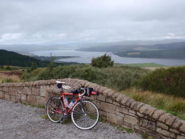
We arrived at Arrochar (8.0m), at the head of Loch Long. The road leaves Loch Long and climbs a wooded valley for over 7 miles. We were very pleased to arrive at the top with the aptly names “Rest and be thankful pass”. I was very thankful despite the 4.7 degrees Celsius temperature.
Due to the cold we were not keen to remain at the top of the pass for long so continued riding now with a long descent down to the shores of Loch Fynne. On the descent we were stopped by road works for about 5 minutes and we quickly got cold again. I squatted behind a car to reduce the gusty cold headwind. We rode past Loch Fyne Oyster Bar and I could smell them. I so like oysters!
At 30.3 miles we arrived in Inverary, having just passed Inverary Castle on our right, a multi turreted mock Gothic Palace which is the family home of the powerful Campbell Clan who have been the Dukes of Argyll since 1701. There is a sign out promoting a coffee shop but thought they may not appreciate 6 Lycra clad middle aged, wet and dirty cyclists in their cafe.
So we lobbed up at another cafe just half a mile on, greeted by a lone bag pipe player. Think he was there for the hoards of tourist buses seemingly full of “old people”. Note to myself: they look very bored, do your own thing!
Leaving Inverary having consumed a bowl of soup and large cappuccino, I immediately regretted that level of liquid consumption as I was far too full for the immediate 7 mile climb. The Scots seem to like 7 mile climbs as this was our third in only a couple of days.
After reaching the top of the climb (37.9 miles), the road descends and continues undulating in woods along the shore of Loch Awe.
Loch Awe is one of the longest freshwater lochs in Scotland, stretching 25 miles across a glen in the south west highlands.
We also past the abandoned Kilchirn Castle, dwarfed by Ben Cruachan.
We arrived at our accomodation at Brander Lodge Hotel at the 52.9 mile mark, having just passed the Cruachan Power Station.
Just down the road is the Pass of Brander where Robert the Bruce fought the Clan MacDougal in 1308. Our route goes past there first thing in the morning on the way to Fort William.
Tony has just checked his Garmin and the temperature range today was between 4 and 10 No wonder we were cold at times. The average was 6 degrees!
Day 16: Bridge of Awe to Fort William: Mama Mia, here we go again..
Monday September 16, 2013, 50 miles (80 km) – Total so far: 839 miles (1,350 km)
I was never, ever an Abba fan so why on earth did that silly song get stuck in my head as we left Bridge of Awe? Kind of annoying! Tried swapping it with Tom Cochrane’s “Life is a highway”, as that seemed more appropriate on the A road today. Today was cruisy! Easy 50 miles in much improved weather conditions. It did drizzle a little but I did not get wet. I upgraded my knicks to my 8 degree and under long Assos pants to ensure warmth.
From Bridge of Awe we rode through Taynuilt (2.9 miles) with the road gently undulating to Connel (9.7 miles). There was a fairly strong headwind at this point and I took my turn at the lead for a mile or so. I am not strong in the wind. It frustrated me.
We then crossed over the large iron bridge that passes over the estuary and we really got blown about by side gusts. I was thankful that it was one way traffic only.
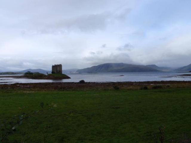
We then rode through Benderloch (12.8 miles), past the Scottish Sea Life centre and then crossed over onto the cycle path. Great path. We stopped to admire and photograph the deserted island castle Streaker. I understand that many do not get to see this castle due to weather conditions but we had a clear and unimpeded view today.
We had arranged with new boss Royal John to stop at the nearby cafe overlooking this castle but our route instructions seemed to include a “steep hill” which we somehow avoided by continuing on the flat bike path. We made the decision not to go climbing any hills in search of this elusive cafe and to proceed to the next town.
A highlight of the morning cycle path was the section that goes through a heavily wooded forest. We saw two red squirrels which were very pretty little creatures, but much shyer than the grey squirrels in Hyde Park, so no photos today.
We rode through Duror at 31.0 miles hoping to find a cafe but alas there were none. Royal John found us here deep in conversation and we told him we could head to Kentallen for lunch. He kindly drove ahead to ensure the local food venue there was open, which it was.
We had a great lunch on the shore of Loch Linnhe. Fantastic views.
We took it even easier in the afternoon so that we would not arrive too early into Fort William. We enjoyed the loch views. We also passed over a bridge crossing that provided spectacular views of Glencoe which is renowned for its beauty and savage history when the Campbell Clan killed 38 of the MacDonald clan in 1692.
North Ballachulish is reached at 37.6 miles and Onich at 39.3 miles, both hugging the shores of Loch Linnhe.
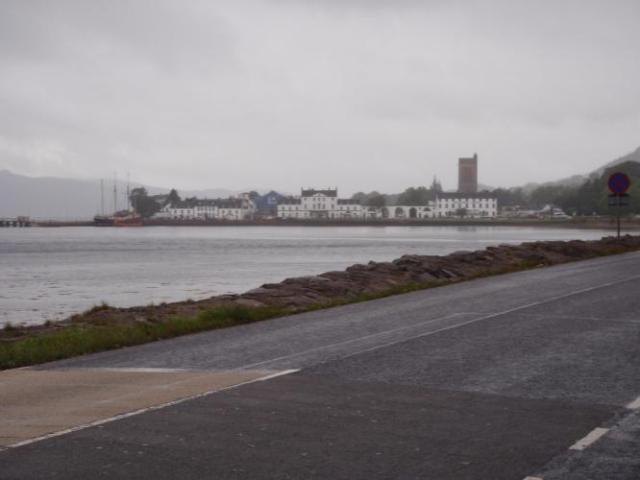
Fort William signaled the end of riding for the day (50.1 miles). Brilliant mountainous setting, Fort William must be the capital of bush walking stores! Certainly there were lots of walkers with backpacks around as Fort William marks one end of the Great Glen.
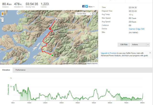
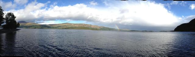
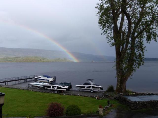
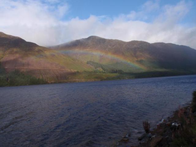
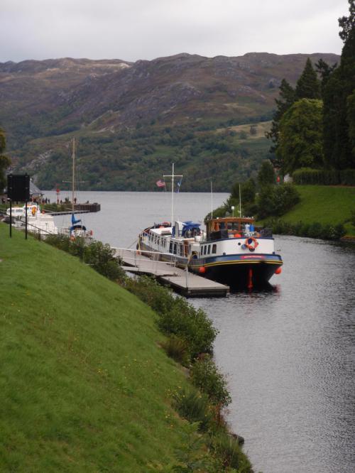
Day 17: Fort William to Drumnadrochit: The land of rainbows
Tuesday September 17, 2013, 52 miles (84 km) – Total so far: 891 miles (1,434 km)
The Great Glen forms a scenic route from Inverness on the Scottish East Coast to Fort William on the west. The glacial Rift Valley was created when the landmass split and moved 400 million years ago. There are a series of four lochs including the famous Loch Ness, Loch Lochy, Loch Linnhe and Loch Oiche. They are interlinked by the Caledonian Canal, built by Thomas Telford, and has been used as a shipping channel since 1822.
Today we saw about four separate rainbows. I guess that is one advantage of drizzle followed by sunshine. Certainly we enjoyed seeing them.
Upon leaving Fort William this morning we were fortunate to be stopped at the Caledonian Canal’s Neptune Staircase to witness that lock working. There are eight locks here and the lock worker told me that it would take them one hour and twenty minutes to get the fishing boat through all 8 locks, rising the water level a total of 21 metres. We were all genuinely fascinated by this engineering feat.
We then headed towards Gairlochy with the road undulating through the valley providing glimpses of Ben Nevis back over Fort William. More rainbows.
We stopped at the top of a climb at around the 10 mile mark as Alan sustained his fourth puncture on his front tyre. Bad luck but this time the tyre was replaced as well. It provided me with a good opportunity to rest my lungs which were suffering in the cold and damp air after the previous climb.
We stopped to look at the Commando Memorial (11.8 mile) on the site of a World War II commando training camp site.
At the 23.8 mile mark we again crossed the Caledonian Canal and passed though Invergarry (26.0 mile).
At the 28.7 mile mark we turned off the road immediately before the bridge over the Caledonian Canal to follow the canal tow path. The first section was quite muddy after recent rain and a bit rough. The path then improved as we progressed towards Fort Augustus.
At one point in this path we rested and located what appeared to be a small snake. Apparently it is a slo worm, a legless lizard.
Lunch was in Fort Augustus ( 33.5 miles). The Caledonian Canal runs through town into Loch Ness. Fort Augustus is a tourist mecca with heaps of tourist buses and camera clicking Asians. You could purchase a very small jar of supposed Loch Ness water for a mere £7. What a rip off!!
After lunch we continued with our cruisy pace hitting Invermoriston (39.9 miles). The road was increasingly undulating this afternoon.
We arrived at Urquhart Castle (50.7 miles) which looked nothing like the photos that I had seen, which disappointed me. I guess they were taken from the water aspect. We viewed the castle from the car park as they wanted £8 to enter the ruins.
We then descended into Lewiston (52.0 miles) and Drumnadrochit. After a little bit of navigational confusion we arrived at our accomodation to be greeted by the home owner Alistair, with homemade chocolate cake. This was very greatly appreciated by all and the cake did not go to waste.
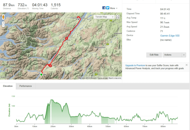
Day 18: Drumnadrochit to Bonar Bridge: It is a long way to the top…
Wednesday September 18, 2013, 51 miles (82 km) – Total so far: 942 miles (1,516 km)
I cannot believe that we are getting so close to John O Groats. Part of me is excited, but another part sad, as I have enjoyed the last three weeks so much, with a great bunch of people, lots of laughs, supported by a great Bike Adventures crew. Nevertheless, the show must go on.
Today I made the decision to leave Drumnadrochit before the rest of the gang, with just Tony in tow. My reason was because of my increasing concerns regarding my lungs and exercise induced asthma. The last few days the air has been cold and I have found that my lungs are going into tightness much more quickly.
This, combined with the fact that there was a significantly steep hill (regarded as the third hardest climb of the tour) to climb out of Drumnadrochit requiring a lot of physical exertion, in the colder part of the day, led to my solo decision. I do not like to have lots of people around me when my asthma plays up.
I ensured, as always that I had both my daily preventive and also the required doses of ventolin. Alan lent me a neck scarf to try and wear over my mouth to warm up the air I was breathing.
So I just grinded away, slowly as I could, concentrating on my breathing, keeping it as regular as I could. I found the neck scarf a little suffocating on climbing but very useful on the flatter sections. I got up the climb without issue which was the important thing! There was heaps of oil on the road making it a little slippery in a few spots.
Tony and I decided to head to Beuly to wait for the rest of the gang as it was damn cold in the drizzling rain. As the road descended it continued through open rolling hills. After we crossed River Beauly, we found a nice little cafe in town (14.8 miles) that was willing to have 2 dripping wet clients even providing paper towel to dry ourselves with. There is a nice old priory in the town, the ruins of which are worth a quick look.
With our group reformed, we continued towards Dingwall, passing through the Muir of Ord (17.3 miles), Conon bridge (20.7 miles, stopping for some coffee and goodies at a cafe in Dingwall (23.2 miles).
Upon leaving Colin discovered he had a puncture on his rear tyre so we rested longer, this time freezing our butts off.
Back on the road we climbed out of the town which continued alongside of the hill. We rode through Evanton (29.9 miles) again climbing across open fields, then descending steeply into the valley. Around this time we met another cyclist from Perth, Western Australia who was riding LEJOG on his own.
After crossing the river, the road climbed yet again steeply through the woods. Ardross is at the 36.0 mile mark and is signified by nothing at all except a sign. Nothing worth stopping for, and Colin’s pit stop would need to wait until we climbed through forest and across open moorland.
A very nice, very fast Ferrari screamed past us at this point, and boy was he moving. John caught up to us with the van asking if we had seen Rodney, Ian and Graham as they had escaped and were missing in action, somewhere!
At the 45.2 mile mark there is a viewpoint over Dornach Firth. Great views. We were enjoying our break until a tourist bus full of bored looking older folks rolled up. Not one of these tourists could crack a smile confirming the need for me to continue acting my mental age rather than that denoted on my birth certificate.
From the viewpoint the road descends steeply and follows Dornoch Firth, entering Kyle of Sutherland.
At 50.1 miles Ardgay is entered and we proceeded directly to Bonar Bridge with its modern looking bridge. Bonar Bridge is a village on the north bank of the Kyle of Sutherland.
Our accomodation was not quite ready so we enjoyed a light meal at a cafe with Rodney, Ian and Graham who had been rediscovered. They had chosen not to stop for any fuel breaks during the day and were making up for it now.

Day 19: Bonar Bridge to Tongue: Stairway to heaven!
Thursday September 19, 2013, 49 miles (79 km) – Total so far: 991 miles (1,595 km)
Today I rode through heaven’s gardens. The ride was quite simply the most beautiful and scenic ride that I have ever done. It was an easy ride providing ample opportunity to bask in natures glory at its best.We left Bonar Bridge with some blue sky! Rain jackets were unnecessary but some chose to wear them until fully warmed up. We followed the river out of town heading towards Lairg. At the 5.0 mile mark we crossed the river and climbed gently along the wooded valley.
We turned into Falls of Shin which are worth stopping to view. Salmon are frequently spotted jumping but not during our brief visit.
We continued along the valley by the river and turned towards Lairg (10.2 miles). Through Lairg (11.2 miles) continuing alongside the loch.
At this point the road north became a single lane track crossing flat open moorland with button like grasses and flowering heather like plants. The road then climbs up through a forestry plantation reaching Crask Inn (24.0 miles).
Royal John had recommended we all stop here as it was the last point of possible nourishment purchase for the day and he regards the place as an “institution”.
I was the first to enter the building and I did wonder if perhaps they were not open today as all the lights were turned off. I called out and no response. I had inadvertently let a dog in when I entered, and after some time a lady wandered out wanting to know how many of us were turning up and what we were after. ” Whatever you have to offer will be gratefully purchased” I told her.
Well out came a plunger of coffee and simply the best cake I have ever eaten with apple and black currant in it. We stayed for the good part of an hour also meeting a couple of other ‘end to enders’ and 3 Flemish guys on motor bikes doing the Tour of Scotland.
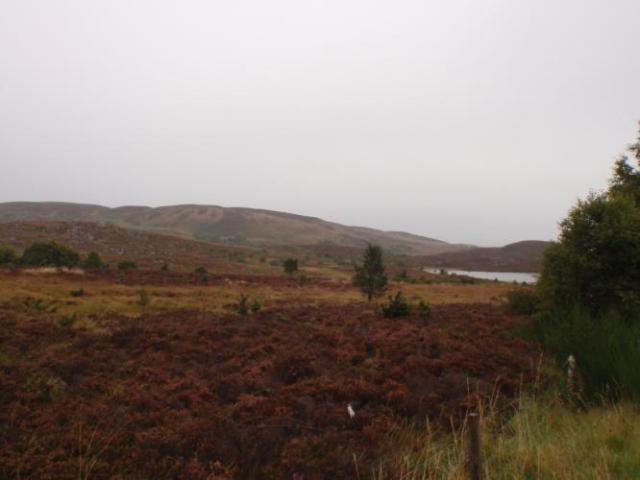
Only a few mile down the road from Crask we were riding through a magnificent valley when we heard a noise which made no sense. Before we really comprehended what was happening we were buzzed, at extraordinary low altitude by what we assume was a British Airforce fighter plane on a very low altitude mission. The noise as it flew over was incredible, as was the sight of its monster rear jets and how it veered through the valley like something out of Star Wars. Wow!!
Altmaharra ( 31.8 miles) looked pretty dead after that entertainment.
We continued through undulating forest and open moorland, crossing over the river and following the shores of Loch Loyal.
We arrived at Tongue after a steep descent in misty rain which soon cleared. Tongue is located on a shallow sea loch, with great views of Ben Hope and Ben Loyal.
Tony and I then walked up to Castle Varrich offering wonderful panoramic views of the inlet out to the heads into the Atlantic Ocean. The castle is an old square tower on a hill on the east side of the Kyle, believed to be the residence of Karl Hundason, who made an effort to conquer Scotland on the death of Malcolm II. The walls are around 1.4 metres thick.
Tomorrow will be bitter sweet. Our goal will be reached marking the end of a wonderful journey and holiday with a great bunch of people. Mixed emotions!!


Day 20:Tongue to John O Groats: Bitter Sweet
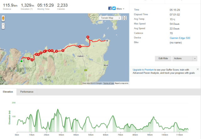
Friday September 20, 2013, 72 miles (116 km) – Total so far: 1,063 miles (1,711 km)
The last day! Three weeks ago this day seemed so far away with a mountain of work in between the start at Lands End and the finale at John O’Groats.With a heavier heart we set off from beautiful Tongue. The Kyle of Tongue was very inviting at the top of the climb out of the village. It was high tide and the shallow Inlet looked serene.
We had climbed Varrich castle hill the previous night after our bike riding for the day had ended and there it stood perched on the edge of the cliff as it has for centuries.
At 2.9 miles we reached Coldbackie and rode through. The road was undulating across open moorland. There was a climb up to Bettyhill (13.0 miles). Some of our group rested on the hill up but I do not like to stop on hills. I find it too hard to get going again so rode on and found some public toilets at the top. I managed to get in and out before the bus of disengaged German tourists lined up.
The route continued up and down arriving at Strathie (22.5 miles) and Mevlich ( 25.7 miles). More hills and more hills and a few more.
Our final county was entered at 29.4 miles, Caithness. Reay is at 32.0 miles and we also went past the Dounreay Nucleur Power Station – with 5 nucleur reactors, it is currently being decomissioned, but that wont finish until 2036, and it will be a brownfield site by 2336. Makes you wonder about the dangers.
We reached the most northerly town on the British mainland Thurso, and old Norse port at 43.5 miles. There are great views towards the Orkney Islands. This is where we were taking a break to allow the riders to consolidate as we wanted to all finish together. It was a tough morning ride as it was quite lumpy.
Nice little bakery in the mall area. As we left, there was a lone bagpiper playing and again I felt melancholy. It was like a lament! I tossed one pound into his hat and was surprised that he could say “Thankyou” and keep the bagpipe noise continuous.
We hit Castletown at 48.8 miles and Dunnetnat 52.0 miles. Easy riding, cool down mode.
Our final climb was to Dunnet Head (56.7 miles) which is mainland Britain’s most northerly point offering more views of the Orkney Islands. Well worth the detour. There are the remnants of fortifications constructed during World War II to protect the naval base as Scapa Flow (Orkneys).
Tony, Helen, Alan and myself waited for Rodney and Ian to arrive so that we could ride with them. I think they were pleased. I tried to gee Ian up a bit as he told me his legs were very tired. Helen left our group and shot off to try and catch up with the others who had not waited at Dunnet Head.
At 64.5 miles we went through Mey passing the front gates to The Prince of Wales owned Castle of Mey, previously owned by the Queen Mother. If not riding with a group I would like to have paid a visit.
Knowing that Tony and I being the stronger two riders could march ahead and probably catch those who had not waited I decided there was more to be gained by supporting others. I was so pleased to see that Colin and Joyce waited on the John O Groats outskirts with Helen and Jane, with Peter waiting on the roadside a little further up the road and then finally Graham at the pub!!
Peter, at 80 years, having raised over £10,000 for his charities, led us in to be greeted by Phil and John with champagne and the obligatory photos.
I am proud of me! At 51 I rode around 1050 miles, climbed over 18,200 metres and sat on my saddle for just over 85 hours. I climbed hills I never thought I could. I met a wonderful bunch of like minded people including an amazing 80 year old retired Minister Peter Langford ( a member of our team to complete LEJOG) who made me think a lot and made me realise that I can do whatever I set my mind to.
In the words of the Monty Python stage show Spamelot that we watched in London a few nights before our epic journey started ” find your grail” ! This was my grail and it is the start of a new passion to do similar rides.
Bring on France 2015: Dover to the Med!!